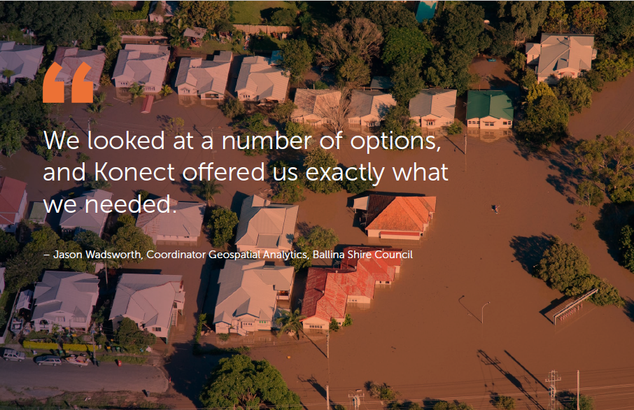
“We looked at a number of options, and Konect offered us exactly what we needed.” – Jason Wadsworth, Coordinator Geospatial Analytics, Ballina Shire Council
In a country all too familiar with catastrophic weather events, the summer floods of 2022, made an indelible mark on the Northern Rivers coastal hub of Ballina. At its peak, The Guardian were reporting, “The SES logged 300 rescues and received 2,202 calls for assistance in the 27 hours. The Richmond River peaked at 7.15 metres at Woodburn, almost two metres higher than its February 1954 peak of 5.42 metres. All that water is now rushing to Ballina, in what authorities warned could be a one-in-500-year flood”.
While the media were reporting at the coal face, a small group from the Ballina Shire Council were already conducting work that would expedite the recovery and alleviate the future risks of similar events. Konect – the only flexible location-based data collection app – was the tool at the forefront of this dynamic and innovative approach, had been with the Shire for barely a few weeks; but it was to prove an invaluable asset.
Jason Wadsworth is the Coordinator Geospatial Analytics at Ballina Shire Council. Located about 770 kilometres north of Sydney and 190 kilometres south of Brisbane, the Council manages a population of 46,000.
Jason explained,
“We were looking for a tool that was intuitive, cost effective and able to be used across IOS and Android. We looked at a number of options, and Konect offered us exactly what we needed.”
When Konect was introduced at the end of 2021, no one could have foreseen the events that were just around the corner. Jason added, “We had only just started to experiment with it; creating some forms and transitioning data. Then the rain came. Because Konect was so intuitive, and once we understood how it interacted with our data, we were able to quickly and easily get it to work in the real world when we most needed it”.
Prioritising assets and data collection during crisis
With that real world involving such catastrophic rain, just how did they prioritise its use? “A major priority was understanding which of our many assets had been affected by the water. In particular, our critical pump stations, which were expensive to replace. We were able to create a form in Konect that recorded flood levels and damage, but also captured photographs. All this proved invaluable not only in prioritising repairs, but also in dealing with the associated insurance claims.”
As well as the immediate needs, the Council was prioritising the collection of additional mapping data, so that they could get good situational awareness of all areas of the Shire. Post flood, Jason is continuing to create a preparedness framework for any future events. “We are now preparing a mobile, emergency environment in Konect that we can quickly deploy with all the forms pre-created. A major issue during the rain event was the breakdown of network communication. By having all the data synchronised on a mobile device prior to a future event, we can respond instantly, and capture everything we need without the need for an immediate upload.”
“Konect has been a significant benefit to both our teams, the Council and the public as a whole.”
With Konect proving its capability from the get go, Jason and his team started looking at other ways it could help in the event’s aftermath. “We were able to assess the rest of our underground assets, such as fire hydrants and water valves that were incapacitated by the flooding and associated silt build up.” Jason is also aligning Konect with the Council’s emergency plans. “By knowing where evacuation centres are, the various flood height levels, and by having photos of assets and infrastructure, Ballina is ensuring that whatever the event, we will be ready to respond.”
In addition to the Council’s immediate needs and the expectations of their populace, they are also supplying data to the public to use in their own insurance claims. Jason explained, “We had one business who needed to have proof of flooding at their premises for their insurance company, to determine, for example, if it was river or storm water. By having time stamped data, we were able to precisely document the time and conditions of the event that affected them”.
In a creative move, Jason and his team also made a public call out after the event for photos taken by members of the public. This proved a major source of ‘new’, readily available data that would have otherwise remained untapped. “The thing is, that with smart phones, the photo comes with a geo location and date and time tag. It meant that we could quickly add that to our Konect and our mapping system.”
Integrating Konect for future preparedness
Using the Konect APIs, and integrating with Intramaps and exiting systems, Ballina Shire is making leaps and bounds in the area of syncing data, to further enhance Konect’s future use. “Real time reporting and activity is the ultimate goal across all aspects of Council service. We can run reports, allocate jobs, detail trends and improve efficiencies across the board”.
So, what about the teams in the field; the hands-on users? “They love it”, Jason added. “Prior to the arrival of Konect, we never really had a field-deployable tool. Real time ‘pushing’ and retrieval of data is now a reality, whereas previously there was really no way to provide immediate information to the field teams.”
The Ballina Shire Council also utilises Konect across a number of other areas. Jason explained, “Konect is being widely used. For example, our entire system of culverts is currently being mapped for the first time to understand the movement of flood waters; our rangers use it to assist when dealing with compliance issues; and with areas like mowing, where contractors are paid per time worked, Konect enables accurate time and financial management.”
With Konect’s role in the Shire firmly in situ, the future is all about further integrations across services, infrastructure and public works, with advanced automation and synchronisation. The data creates cost savings, and detailed evidence to support grant applications, development and strategic planning. With over 485 sq km, the opportunities for Konect to ply its trade have barely been touched on; but its start has been impressive.
Jason concludes,
“The ability for us to get information to and from the field is one of the main motivations for Council’s full support when it comes to advancing Konect at such a rate. Our field teams have always struggled to have information about assets and other details at their fingertips. And we’ve struggled to update them in a timely manner. To that end, Konect has been a significant benefit to both our teams, the Council and the public as a whole.”